Properties, Directions and Hours
 Waquoit Bay Reserve Headquarters
131 Waquoit Highway, Waquoit (East Falmouth), MA 02536
Hours: The Reserve Headquarters/Offices are open Monday-Friday from 9:00AM-5:00PM.
The Visitor Center is open Monday – Saturday from 10:00AM – 4:00PM.
From Boston:
Follow Route 3 South to the Sagamore Bridge over the Cape Cod Canal. Route 3 crosses over the bridge and becomes Route 6.Take Exit 2 (Route 130). Turn right off the ramp and follow 130 South 7.2 Miles to Great Neck Road, just after Dunkin Donuts (which is on the left). Turn right onto Great Neck Road and follow it to the Mashpee Rotary. Halfway around the rotary, take Route 28 North toward Falmouth/Woods Hole. The Reserve is located 3.5 miles from the rotary on the left. The Reserve’s offices are located on the second floor of the main building. Follow the signs to the Visitor Center.
From Providence and Points West:
Follow Route 495 or 195 to Route 25. Route 25 crosses over the Bourne Bridge and becomes Route 28. Follow Route 28 South to Route 151 (first exit after the Otis ANGB/Cataumet Rotary). Turn right off the ramp and follow 151 under the bridge to the Mashpee Rotary. At the rotary, take Route 28 North toward Falmouth/Woods Hole. The Reserve is located 3.5 miles from the rotary on the left. The Reserves offices are located on the second floor of the main building. Follow the signs to the Visitor Center.
From Falmouth:
Proceed south on Route 28 (toward Mashpee). The Reserve is located a just under 2 miles from the Davisville lights in East Falmouth (1 mile from Mahoney’s Garden Center and 0.5 miles from White’s Landing/Edward’s Boat Yard/Childs River) on the right after the Waquoit Cemetery. The Reserve’s offices are located on the second floor of the main building. Follow the signs to the Visitor Center.
From the East:
Follow Route 6 to exit 5 (Route 149). Follow 149 South towards Marstons Mills to Route 28. Take a right on 28 North (towards Falmouth). Follow Route 28 around the Mashpee Rotary and continue on 28 North towards Falmouth/Woods Hole. The Reserve is located 3.5 miles from the rotary on the left. The Reserve’s offices are located on the second floor of the main building. Follow the signs to the Visitor Center.
 Directions to South Cape Beach State Park:
GPS address: 494 Great Oak Road, Mashpee, MA 02649
South Cape Beach State Park, Mashpee
Fee charged 9AM-5:30PM daily beginning Father’s Day Weekend.
MA Resident Vehicle – $12, Non-MA Resident Vehicle – $40
Mobile & Online Payment Information for Parking Statewide
Parking Information at Massachusetts State Parks
From the East/Mashpee Rotary:
From the Mashpee Rotary follow Great Neck Road (south) toward New Seabury. Turn left at the main entrance, marked with a State Park sign. Between Columbus Day and mid-June proceed to the Mashpee Town Beach parking lot at the end of the entrance road. No sticker is required in winter to park at the town lot.
From the West/Reserve Headquarters:
Proceed south (right out of the entrance to Reserve Headquarters) 1.3 miles to Red Brook Road (on the right across from Martin Road). Turn right onto Red Brook Road and follow it to the end (2.2 miles). Turn Right onto Great Neck Road and proceed 2.1 miles to the entrance to South Cape Beach. The entrance is marked with a State Park sign. Between Columbus Day and Patriots Day proceed to the Mashpee Town Beach parking lot at the end of the entrance road. No sticker is required in winter to park at the town lot.
Washburn Island Day and Camping Use Guide – https://waquoitbayreserve.org/visit-the-reserve/camping/
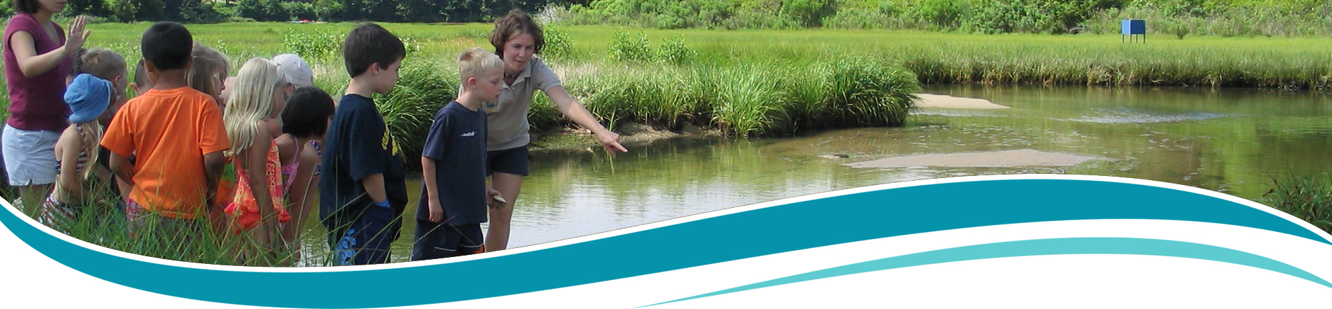
The Massachusetts Department of Conservation and Recreation (DCR), manages the island as a part of the Waquoit Bay National Estuarine Research Reserve. The Reserve’s main purpose is to foster research and education on coastal systems. We support recreation as a way to allow people to become more familiar with these special places.
Washburn Island is one of the last large undeveloped coastal properties on Cape Cod and a jewel within the Reserve. Habitats consist of a barrier beach, oak and pine forest, and coastal salt ponds. Most of the present vegetation on the site dates from after World War II. Today, the island has ten campsites supported by three composting toilets – nine family sites and one group site that is limited to 25 people. There are also trails on the island for nature viewing and exploration.
Day-use parking is available at the public/town owned boat launch White’s Landing on Route 28. Town of Falmouth Boat Ramps.
Properties of the Reserve
The Waquoit Bay Reserve comprises approximately 2800 acres of land and water. In addition to the Headquarters facility, South Cape Beach, and Washburn Island, which were all acquired at the outset, other lands have been added to the Reserve as they have become available. These acquisitions were chosen because they represented significant habitat value. See Land Acquisition.
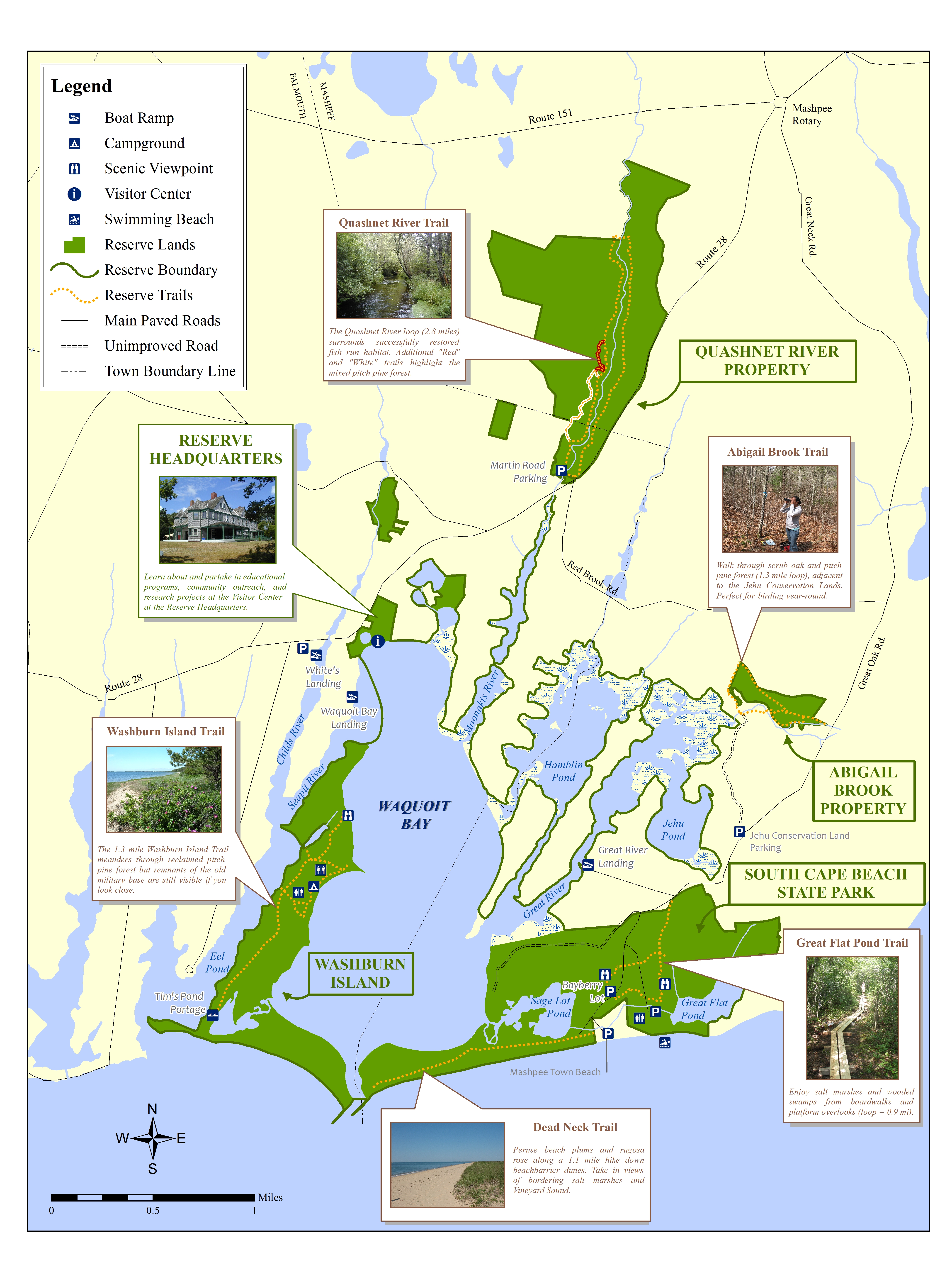
To print or view this map larger please click here.

Waquoit Bay
Acres: 825
Habitat: Fresh water enters the Bay from 4 principal sources; the Quashnet/Moonakis River, Red Brook, Childs River, and ground water flow.
History: Salt water enters through two maintained channels and a new inlet created by Hurricane Bob in 1991. It is relatively shallow (maximum depth 9 feet, average depth less than 3 feet). It is a little over 2.5 miles from the entrance at the southern end to the Reserve Headquarters at the northern end.
Recreation: Kayaking, sailing, power boating, fishing, birding.

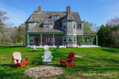
Visitor Center
The Reserve’s headquarters are located in the historic Sargent Estate, including a Visitor Center, staff offices, laboratory, education programs, short walking trails, and picnic area. The Visitor Center is open seven days per week during the summer months from 10:00AM – 4:00PM.
131 Waquoit Highway
Waquoit, MA 02536
Tel: 508.457.0495
Waquoit.Bay@mass.gov

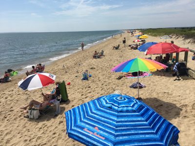
South Cape Beach State Park
Parking (fee in-season) for South Cape Beach, a barrier beach on Vineyard Sound. Swimming, fishing. South Cape Beach is an important nesting area for protected shorebirds like piping plovers, oyster catchers and terns. No dogs on beach March 15 – September 1. Seasonal port-a-johns, changing booths, wheelchair accessible boardwalk to deck overlooking beach. Beach wheelchair is available; call 508-457-0495 to reserve the chair. This property is part of the Waquoit Bay National Estuarine Research Reserve.

Washburn Island
Washburn Island is a 300 acre island located on Vineyard Sound on the south side of Cape Cod. The barrier beach provides important nesting areas for shorebirds including the piping plover, oyster catcher and tern colonies. Camping is also available from late spring – early fall.

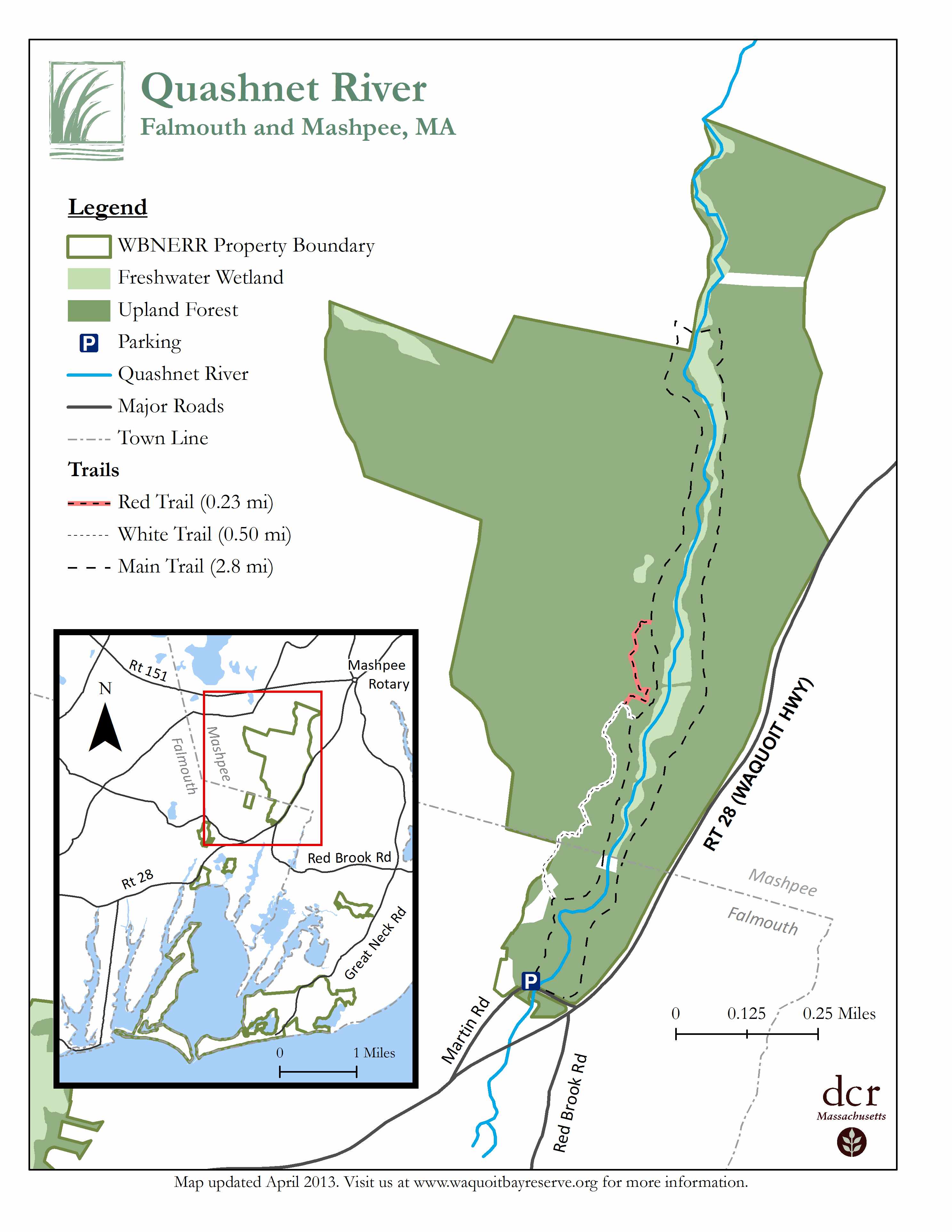
Quashnet River Trail
There are several miles of walking trails along the Quashnet River, one side of a restored trout stream on a fire road over a herring run and back down the other side on a trail. There is a small parking area on Martin Road, E. Falmouth which also includes historical and restoration efforts information. Map of the trail.

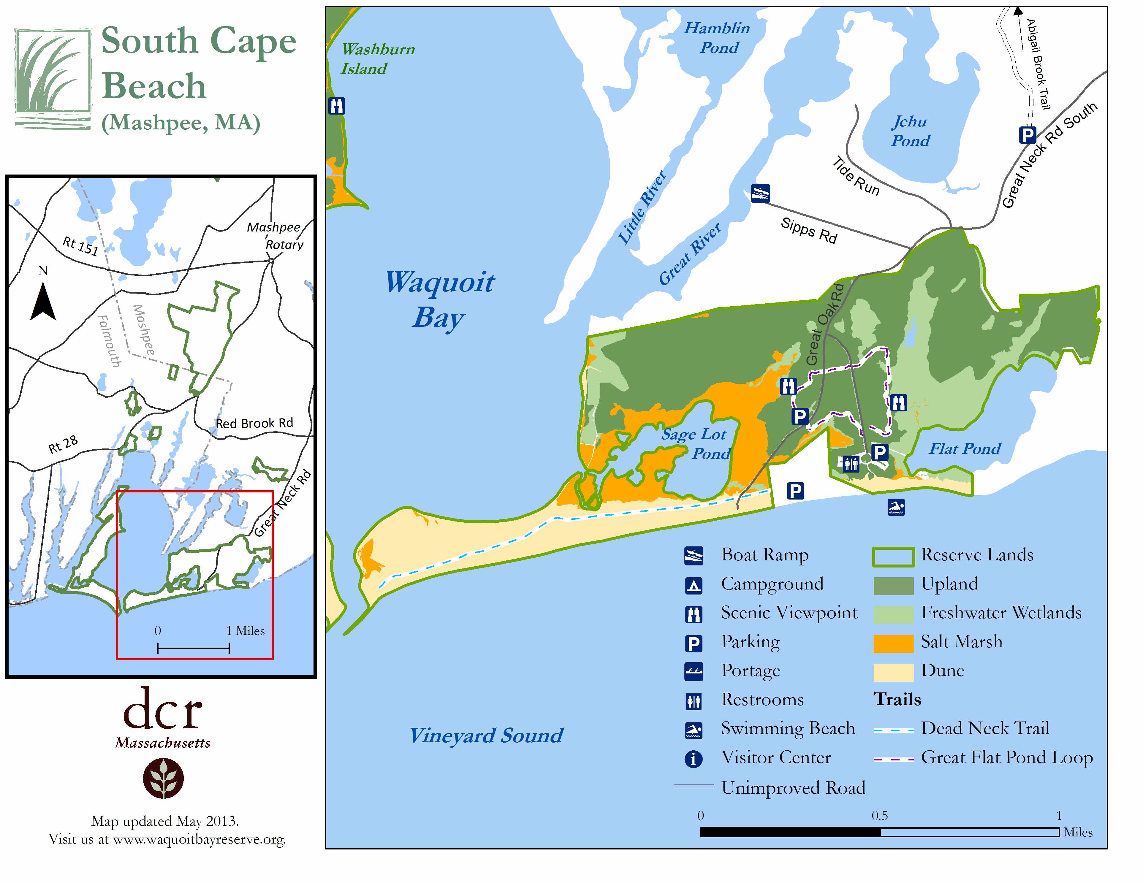
Dead Neck Trail
Located at South Cape Beach State Park is a sandy walk to the jetty into Waquoit Bay with views of Vineyard Sound and Sage Lot Pond, salt marshes, and dunes. South Cape Beach is an important nesting habitat for shorebirds. Areas are marked off to prevent the nests from being disturbed by people and pets. View trail map.

Great Flat Pond Trail Loop
Located at South Cape Beach State Park walks feature upland forest, boardwalks and viewing platforms over salt and freshwater marshes. Parking is available at Bayberry Lot. View Trail Maps.

Caleb Pond
Accessible at high tide by kayak or canoe from Waquoit Bay, Caleb Pond is a freshwater pond that drains into the bay. This property is part of the Waquoit Bay National Estuarine Research Reserve.
